Snowdon walking routes-LLlanberis Path
Llanberis Path is the easiest and longest of the six main paths to the summit of Snowdon. Originally, tourists were carried up this path on ponies and mules, and to this day it continues to be a pony path.
Distance: 9 miles (there and back)
Total Climb: 975m (3,199 ft)
Time: Approx 6 hours (there and back)
Start and Finish: Far end of Victoria Terrace, Llanberis, off the A4086
Map: OS Explorer OL17
Parking: Numerous car parks in Llanberis (LL55 4TD)
Sherpa Bus Stop: Llanberis Interchange

Snowdon walking routes-Miners Track
Following the opening of the Llanberis pass in 1832, the Miners Path was built to carry copper from the Britannia Copper Works near Llyn Glaslyn to Pen-y-Pass, where it was then transported to Caernarfon. The mining came to an end in 1916, remains from the work can still be seen on the path to this day.
Distance: 8 miles (there and back)
Total Climb: 723m (2,372 ft)
Time: Approx 6 hours (there and back)
Start and Finish: Pen-y-Pass Car Park (SH 647 557 / LL55 4NY)
Map: OS Explorer OL17
Parking: If the car park is full and you are keen to walk from Pen-y-Pass you can use the Snowdon Sherpa Park and Ride Service running from Nant Peris and Llanberis car parks. Full timetables can be found on the website.
Sherpa Bus Stop: Pen-y-Pass Car Park

Snowdon walking routes-Pyg Track
There is some uncertainty about the origin of the word Pyg. It is believed that the path was named after Pen y Gwryd Hostel by climbers who stayed there. Another possible origin is that the path was named after Bwlch y Moch (the pass of pigs) since the path crosses it, as it is sometimes spelled as Pig in English. Or it could have been named Pyg due to the fact that this was a path used to carry pyg (black tar) from the Britannia Copper Works in Cwm Glaslyn. The guessing continues!
Distance: 7 miles (there and back)
Total Climb: 723m (2,372 ft)
Time: Approx 6 hours (there and back)
Start and Finish: Pen-y-Pass Car Park (SH 647 557 / LL55 4NY)
Map: OS Explorer OL17
Parking: From 1st April 2023 parking needs to be prebooked on the justpark app. If you havent booked and you are keen to walk from Pen-y-Pass you can use the Snowdon Sherpa Park and Ride Service running from Nant Peris and Llanberis car parks. Full timetables can be found on the website.
Sherpa Bus Stop: Pen-y-Pass Car Park

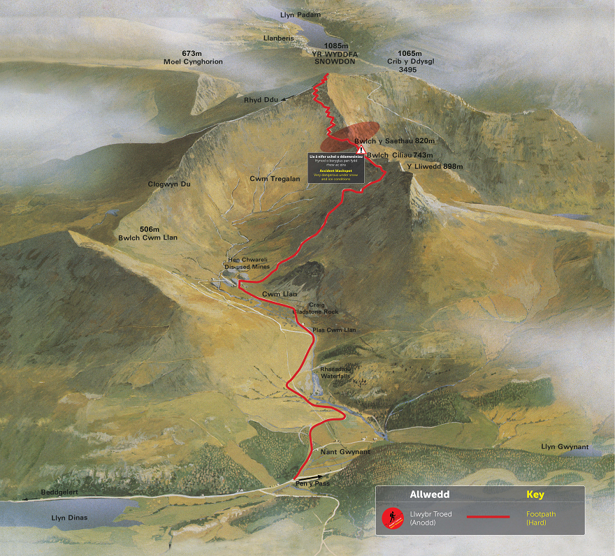
Snowdon walking routes-Watkin Path
This path was named after Sir Edward Watkin, Liberal Member of Parliament and a railway entrepreneur. Watkin had a summer house by the start of the path and he was responsible for creating the path from South Snowdon Slate Quarry to Snowdon’s summit. Officially opened in 1892 by William Gladstone, the Prime Minister, on a boulder by the path which has been named after William Gladstone he addressed a crowd of over 2,000 people.
Distance: 8 miles (there and back)
Total Climb: 1,015m (3,330 ft)
Time: Approx 6 hours (there and back)
Start an Finish: Pont Bethania Bridge Car Park, Nant Gwynant, off the A498 (SH 627 507/ LL55 4NL)
Map: OS Explorer OL17
Parking: Pay and Display Pont Bethania Bridge Car Park (SH 627 507/ LL55 4NL)
Sherpa Bus Stop: Nant Gwynant Car Park
Snowdon walking routes-Rhyd Ddu Path
This path used to be known as the Beddgelert Path since it was from this village that walkers started their journey to the summit.
Distance: 8.5 miles (there and back)
Total Climb: 895m (2,936 ft)
Time: Approx 6 hours (there and back)
Start and Finish: Rhyd Ddu Car Park (SH 571 526 / LL54 6TN)
Map: OS Explorer OL17
Parking: Pay and Display Rhyd Ddu Car Park (SH 571 526 / LL54 6TN)
Sherpa Bus Stop: End of Rhyd Ddu Car Park


Snowdon walking routes–Snowdon Ranger
The path begins near the ‘Snowdon Ranger’ youth hostel, near Llyn Cwellyn. John Morton the self proclaimed ‘Snowdon Ranger’ used the path to guide Victorian tourists to the summit. He also opened a tavern where the youth hostel site stands today, and called it the ‘Snowdon Ranger Inn’.
Distance: 8 miles (there and back)
Total Climb: 936m (3,071 ft)
Time: Approx 6 hours (there and back)
Start and Finish: Llyn Cwellyn Car Park, off the A4085 (SH 564 551 / LL54 7YT)
Map: OS Explorer OL17
Parking: Pay and Display Llyn Cwellyn Car Park (SH 564 551 / LL54 7YT)
Sherpa Bus Stop: Llyn Cwellyn Car Park
Snowdon Paths and Sherpa Bus Service
Planning your transport and parking should form an essential part of your plan for climbing Snowdon. With over ½ a million visitors every year visiting the mountain, car parks can often be full in the warmer months by 7am! If you can we suggest coming during the week rather than on a weekend, and avoiding school holidays. Late September and early October can be a great time to visit.
Details can be found in our paths guide below on the best parking and transport options for each path. If you plan on walking up the Pyg or Miners track we highly recommend using the Sherpa bus. You can view and download the from the Gwynedd Council .
For up to date prices for the Sherpa bus to get you to the start of Snowdon walking route please see HERE!
Local taxi operators also offer services along popular routes including and .
Mountain Guides
If you’re looking for guides to help you on the mountains and give you a memorable experience then please visit our . There’s plenty to choose from including , , and .
Organised and Competitive Events and Charity Walks
Here are some interesting secrets about Snowdon.
- In 1639 came the first recorded ascent of Snowdon, by Thomas Johnson.
- Morris Williams, a miner, was the first to sell refreshments at the summit in 1838.
- Edmund Hillary trained on Snowdon before conquering Mount Everest.
- You can find a rare flower on Snowdon, . A delicate, artic-alpine flowering plant which has grass like leaves. Although it has wide spread distribution in alpine and arctic regions, Snowdonia is its only known location within the UK. Here, they grow on north/north-east facing cliffs, and can be found in a few inaccessible ledges and rock faces, out of reach of grazing animals. It is thought to have survived on high mountains tops within Snowdonia since the end of the last ice age, on areas which remained free from ice sheets and glaciers.
- Snowdon is said to be the tomb of the giant Rhitta Gawr. Rhitta wore a cloak made of men’s beard and was killed by the legend King Arthur.